Using existing technology to safely manage cross-jurisdictional pursuits
Police departments can now hand off surveillance of vehicle pursuits from one jurisdiction to another safely, quickly, and at minimal risk to the public
Sponsored by StarChase
PoliceOne Brand Focus Staff
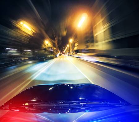
High-speed pursuits are a deadly problem for U.S. police departments. According to the U.S. Department of Justice, an average of 355 people were killed in high-speed pursuits every year between 1996 and 2015. That’s almost one person per day. In addition, there are upwards of 50,000 injuries per year from pursuit related events. The resulting financial strain is in the billions.
With statistics like these, it is no wonder that police departments are seeking safer alternatives to high-speed pursuits. At the same time, they still need to apprehend the vehicular perpetrators who are putting themselves, officers and the public at risk by escaping police at excessive speeds.
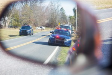
This conundrum only gets tougher when high-speed pursuits cross jurisdictional lines. Even with lots of warning, it is difficult for one police department to have cars in place ready to take over a pursuit from a neighboring jurisdiction. When they do succeed in taking over, the dangers inherent in any high-speed pursuit remain.
Addressing these issues is a big concern for Californian communities in Contra Costa County, including the cities of Pittsburg and San Pablo. Working together, their police departments have come up with a solution to this problem by leveraging their existing traffic cameras, automated license plate readers, and launchable GPS tags supplied by StarChase.
CONNECTING THE DOTS
Traffic cameras are a fixture in much of Contra Costa County. In the cities of Pittsburg and San Pablo, real-time videos are scanned by automated license plate readers (APLRs), which run the plates against stolen vehicle reports.
Cameras aimed at Interstate 80 are helping these departments detect and deter the increasing number of gang-related shootings taking place on I-80. The reason: The ALPRs alert the department to stolen vehicles typically used in such shootings as they hit the highway, often before the shootings actually take place.
The good news is that existing traffic cameras and ALPRs are identifying a record number of stolen vehicles as they move through Contra Costa County. This is an effective repurposing of existing city infrastructure.
The downside: More detected stolen vehicles on the I-80 means more police pursuits, which means more cross-jurisdictional handoffs.
The cities of Pittsburg and San Pablo are now working together to coordinate these hand-offs, aided by StarChase’s GPS tracking tags and AppTrac-365, their secure tracking app, together, they allow command staff, at multiple jurisdictions, simultaneously insight into the event. The result has been more vehicles intercepted and more arrests, with reduced risk to officers and the public.
MAKING PURSUITS SAFER
StarChase’s pursuit management system uses less-lethal GPS tags, which are aimed by vehicle-mounted or hand-held compressed air launchers at the suspect vehicle. The heavy-duty adhesive on the GPS tag enables the tag to stick firmly to the suspect vehicle, “tagging” it like a radio-tagged wild animal. The GPS tracker then sends real-time positional data to the agency’s StarChase web-based mapping platform.
Viewable at dispatch and on laptops, mobile data terminals, and smartphones, StarChase’s secure mapping displays (and records) the GPS-tagged vehicle’s real-time position on a computer street map, not dissimilar to Google Street View. This eliminates or minimizes the need for law enforcement to pursue the suspect in a traditional high-risk pursuit. Instead, officers use the GPS mapping data to plan and coordinate an adrenalin-free intercept of the vehicle down the road, or wherever law enforcement chooses to make the safe stop of the suspect. With this smart technology, command and control remain with law enforcement. And the suspect is no longer leading how the event will end.
One immediate safety benefit of the StarChase system: Data shows that as soon as the suspect believes that they are no longer being chased, they slow down. With reduced speed comes a significant reduction in risk of injury and loss of life.
THE CROSS-JURISDICTIONAL SOLUTION
When neighboring police departments use the StarChase pursuit management system – as is the case with Pittsburg and San Pablo – potentially life-saving results can occur.
Specifically, the two can keep each other alerted on fleeing/tagged vehicles approaching each other’s jurisdictions, monitor the same real-time tracking data on their secure StarChase mapping program and have cars in place to intercept the fleeing offenders in a tactical, low-adrenalin, low-speed manner.
Based on a recent IACP (International Chiefs of Police) presentation given by Pittsburg PD Captain Steve Albanese and San Pablo PD Lieutenant Mike Gancasz, titled “Multiagency Coordination Leveraging Existing City Infrastructure,” working together has delivered impressive results.
Since the StarChase technology was deployed by the two departments, their police vehicles have fired 230 GPS tracking darts at fleeing vehicles with 171 recorded hits, a success rate of 74%. More importantly, the joint efforts of Pittsburg and San Pablo have contributed to 113 arrests.
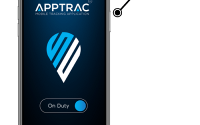
Worth noting: The same StarChase system can be used to track the GPS locations of police cars in real time, and to report when their speeds exceed pre-set maximums. This can be extremely helpful at the dispatch level in tracking which resources are involved in high-speed pursuits or able to render assistance in interceptions ahead of the fleeing vehicle. In addition, an app-based officer tracking tool provided by StarChase, AppTrack-365, enables an agency to track in real time all their officers whether on patrol or on foot. This combination of tools enables law enforcement to gain tactical visibility of both the suspect and their blue line force.
A BETTER, SAFER WAY TO REDUCE RISK AND CAPTURE THE VEHICLE SUSPECT
In a perfect world, high-speed chases would only take place in movies using trained stunt drivers on closed sets. No one would be injured or die due to a suspect’s dangerous driving and terrible impulse decisions, often made worse by alcohol and drugs.
No one knows better than police that this isn’t a perfect world, and that irresponsible, self-centered criminals think nothing of putting other people’s lives at risk as they race down the road in stolen cars.
The combination of inter-departmental cooperation, StarChase pursuit management technology and AppTrack-365 significantly reduces the risks when apprehending these criminals. By GPS tagging suspect cars, police can instantly de-escalate high-risk vehicle events and effect a reduced-risk suspect capture.
At the same time, the power of StarChase’s AppTrac-365 allows agencies full visibility of blue line resources during coordination of these reduced-risk suspect capture events. When used, this technology has shown its ability to increase officer and public safety, even when the event crosses jurisdictional boundaries.
The bottom line: It is possible to apprehend fleeing /high-risk vehicles safely, efficiently, and with high levels of success when agencies use StarChase risk-reducing technology.